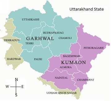
Uttarakhand District Map PDF Download
Uttarakhand was formed on the 9th November 2000 as the 27th State of India, when it was carved out of northern Uttar Pradesh. Located at the foothills of the Himalayan mountain ranges, it is largely a hilly State, having international boundaries with China (Tibet) in the north and Nepal in the east. On its north-west lies Himachal Pradesh, while on the south is Uttar Pradesh. It is rich in natural resources especially water and forests with many glaciers, rivers, dense forests and snow-clad mountain peaks. Char-Dhams, the four most sacred and revered Hindu temples of Badrinath, Kedarnath, Gangotri and Yamunotri are nestled in the mighty mountains. It’s truly God’s Land (Dev Bhoomi). Dehradun is the Capital of Uttarakhand. It is one of the most beautiful resort in the submountain tracts of India, known for its scenic surroundings. The town lies in the Dun Valley, on the watershed of the Ganga and Yamuna rivers.
Uttarakhand Area:53,483 sq.km.
Uttarakhand Population: 101.17 lakh
Uttarakhand Capital: Dehradun(Temporary)
Uttarakhand Districts: 13
Uttarakhand Literacy Rate: 79.63%
Uttarakhand Latitude: 28°43′ N to 31°27′ N
13 District in Uttarakhand Name List: Almora, Bageshwar, Chamoli, Champawat, Dehradun, Haridwar, Nainital, Pauri Garhwal, Pithoragarh, Rudraprayag, Tehri Garhwal, Udham Singh Nagar and Uttarkashi
